

Beschrijving
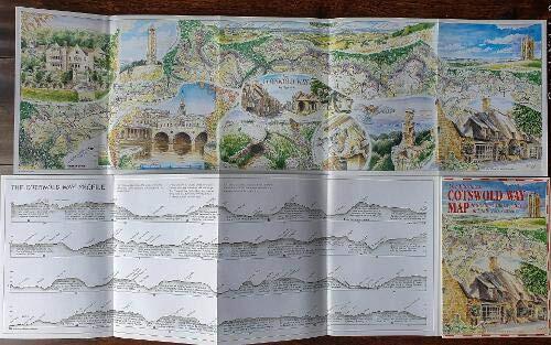
This Map Un-folds from an A5 booklet cover to show the whole 104 miles of the Cotswold Way in full colour, fully illustrated by the international cartographer and artist Roger Ellis. It shows not only the Cotswold Way footpath winding its way between Chipping Campden and Bath but also the major attractions seen along the Way. A must for anyone who has walked or is planning to walk this famous long distance trail Extra Cross sections of the gradients covering the whole Cotswold Way route are shown along with details of what you see or pass along the way, contour shaded to show relief. Contains 10 detailed watercolour illustrations showing views and major features. Scale I in. to 2 miles. Easy to display as a map or guide. Can also be supplied un-creased, rolled and in a tube ready for framing as a souvenir of the walk. A publication by REARDON PUBLISHING the Cotswold Publisher a family run publishing house based in the Cotswolds using local authors and having the books printed in the Gloucestershire Cotswolds, Reardon Publishing are also able to offer a whole range of Cotswold books along with maps and videos mostly in the specialised subjects of Walking, Cycling, Driving, and tourism in both the Cotswolds and associated Counties.
Boekdetails
Formaat
Paperback
Taal
Engels
Gepubliceerd
okt. 1, 1996
Uitgever
GARDNERS VI BOOKS AMS006
ISBN-10
1873877196
ISBN-13
9781873877197